Von Sivers - Chapter 18 Dashboard Image Analysis
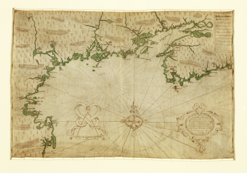
Samuel de Champlain's Map of the Northeast Coast of North America, ca. 1607
In May 1603, an expedition financed by French fur merchant Aymar de Chaste reached the eastern shores of North America. Onboard one of de Chatse’s three vessels was an ambitious young geographer named Samuel de Champlain (1567 - 1635). Though Jacques Cartier had explored the interior in 1534, by 1600 French leaders had come to realize that the only significant revenue to be gained in their corner of the New World was the fur trade.
A place suitable for settlement required considerable geographic research. Frenchmen needed to reside near or within easy traveling distance to the indigenous communities selling furs. They also required a sheltered harbor with easy access to the ocean so that the purchased pelts could be speedily transported overseas. And finally, they needed a defensible place where they could repulse a potential assault from European competitors. For information on the both fur routes and safe harbors, native input was crucial.
After returning to France for the winter, Champlain embarked the following year on a ship owned by de Chaste’s successor, who wanted to find a warmer area to settle. Champlain surveyed the “southerly” coasts of what today are the states of Massachusetts, New Hampshire, and Maine. But Champlain dismissed them all before returning north. While these regions were both warmer and habitable, the natives of these more southerly coastal regions were not fur traders. The only record of Champlain’s journey is this map. It shows the entire northeast coast from the Bay of Fundy (in today’s Nova Scotia, Canada) to Connecticut.
While Champlain took his own measurements, information provided by Indians directly influenced his map. On his voyage south, Champlain notes that the natives pointed out that he had missed the entire mouth of the Merrimack River (one of the largest rivers in the northeast) because the entrance was partially hidden by an island. In what is today Rockport, Massachusetts (indicated as “Cap Blanc” on the map), natives sketched a map of Massachusetts Bay from Cape Ann to Cape Cod, including Boston Harbor.
Source: Courtesy of the Library of Congress