Von Sivers - Chapter 18 Dashboard Image Analysis

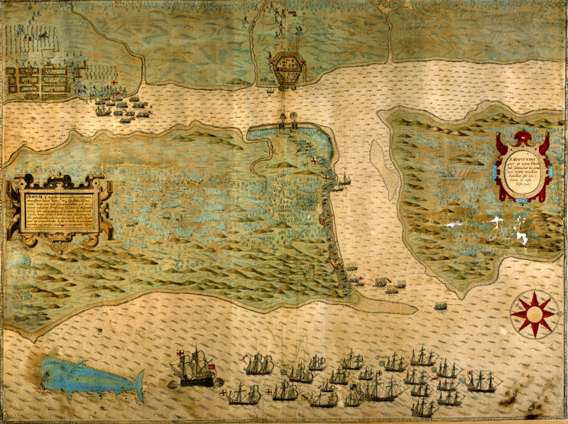
Engraving Showing English Attack on the Spanish Settlement of St. Augustine, Florida (1589)
Italian artist Baptista Boazio created this hand-colored engraving to accompany A summarie and true discourse of Sir Francis Drake's West Indian Voyage, published in London in 1588-1589. Part of a series of maps, this engraving, created in 1589, shows the English conquest of St. Augustine, Florida by the ships of Sir Francis Drake from 1585-6. It is the earliest engraving of any locality in the United States. It shows the English fleet at anchor, while its infantry troops attack the Spanish settlement.
Tensions between England and Spain were high after England supported Dutch rebels against Spanish rule in 1585. While war was not yet officially declared, Elizabeth I allowed privateers, supported by the crown, to harass Spanish trade routes and settlements. The privateer Drake took 23 ships to the Caribbean and Florida in 1586 and successfully captured in the name of England the settlements of St. Iago, St. Domingo, Cartagena, and St. Augustine. The map shows the fleet at port along the coast of the settlement of St. Augustine and the men disembarking to secure the territory. The flags of England, the cross of St. George on white background, mark the ships and indicate the English have already claimed the coast. (This flag of England was replaced by the Union Jack in 1606 after the Stuart kinds united England and Scotland.) Toward the top of the image, the log stockade of San Juan de Pinos is shown firing its cannon across the water toward other cannon being captured by a line of English soldiers moving up the coastline from their ships. The stockade only fired a few shots and most of the Spanish defenders fled before the larger English force invaded the fort. Drake and his men captured the fort's guns and burned the settlement and crops to the ground before sailing north to resupply the English colony of Roanoke in North Carolina.
On the right, the title of the map is set in Latin: "St. Augustine: Part (Below Thirty Degrees Latitude) is on the Mainland of Florida, but the Sea Coast is More Low-Lying and thus Torn Away and Rendered Island-Like.") The text to the left tells us that the homes of St. Augustine were built of wood and were situated among pleasant gardens, that the garrison consisted of 150 men, with as many more at Fort St. Helen (Jacksonville) to the north, and that these garrisons were placed there not because the Spaniards wanted the territory but so that they could keep out the English and French.
The large fish on the bottom left is a mahi-mahi, also known as a dolphin fish, which Boazio most likely copied from drawings by John White, governor of the Raleigh settlement in what was then Virginia (present-day North Carolina).
Source: Courtesy of the Library of Congress