Image – Samuel de Champlain’s Map of the Northeast Coast of North America (1607)
Samuel de Champlain’s Map of the Northeast Coast of North America (1607) Page 55
Chapter 2
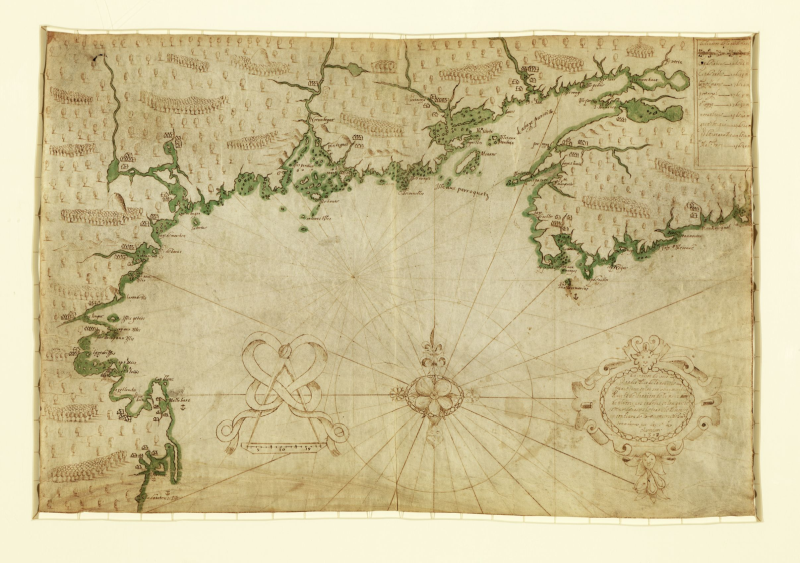
Samuel de Champlain's Map of the Northeast coast of North America, ca. 1607
In May 1603, an expedition financed by French fur merchant Aymar de Chaste reached the eastern shores of North America. Onboard one of de
A place suitable for settlement required considerable geographic research. Frenchmen needed to reside near or within easy traveling distance to the indigenous communities selling furs. They also required a sheltered harbor with easy access to the ocean so that the purchased pelts could be speedily transported overseas. And finally, they needed a defensible place where they could repulse a potential assault from European competitors. For information on both fur routes and safe harbors, native input was crucial.
After returning to France for the winter, Champlain embarked the following year on a ship owned by de Chaste’s successor, who wanted to find a warmer area to settle. Champlain surveyed the “southerly” coasts of what today are the states of Massachusetts, New Hampshire, and Maine. But Champlain dismissed them all before returning north. While these regions were both warmer and habitable, the natives of these more southerly coastal regions were not fur traders. The only record of Champlain’s journey is this map. It shows the entire northeast coast from the Bay of Fundy (in today’s Nova Scotia, Canada) to Connecticut.
While Champlain took his own measurements, information provided by Indians directly influenced his map. On his voyage south, Champlain notes that the natives pointed out that he had missed the entire mouth of the Merrimack River (one of the largest rivers in the northeast) because the entrance was partially hidden by an island. In what is today Rockport, Massachusetts (indicated as “Cap Blanc” on the map), natives sketched a map of Massachusetts Bay from Cape Ann to Cape Cod, including Boston Harbor.
Questions for Analysis
1. Examine the map closely. Compare it to a modern map of the same area. How accurate is Champlain’s map? Which geographical features are portrayed inaccurately?
2. The cartographic assistance Champlain received from the Indians provides evidence of the support European settlers often received from Native Americans. How does this contrast with most accounts of the encounter between Europeans and Indians in the New World?